

Metoceanic Satellite Products
ORBTY provides real-time and historical meteorological and oceanographic data.
ORBTY exploits recent advances in computer vision, machine learning and Artificial Intelligence (AI) to produce high quality Metocean datasets.
ORBTY has adopted an innovative approach for the synergetic exploitation of Earth Observations derived from multiple satellite instruments and provides on-demand products for meteorological/oceanographic agencies and private/public users.
ORBTY's innovative system, the Metocean Multi-Dimentional Dynamic Data Fusion System (M3DFS) ingests Level 2P data and produces Level 3 maps with significantly improved representation of the spatio-temporal distribution of geophysical parameters.
ORBTY's Earth Observation processing framework mitigates major data quality issues that may appear at various satellite product levels and which include:
Sensor noise (Gaussian, striping) in Level 1B radiances/brightness temperatures,
Cloud detection (i.e., undetected clouds or ocean fronts misclassified as clouds),
Artifacts due to time compositing and multi-sensor merging/collating.
Operational Products
Near real-time and reprocessed*
- Sea Surface Temperature from Infrared radiometers (Terra/Aqua MODIS, SNPP/ N20 VIIRS),
- Chlorophyll-a concentration from Optical radiometers (MODIS, VIIRS, OLCI, MERIS, SeaWiFS),
- Wind speed from passive microwave radiometers (AMSR-E, AMSR2, GMI, TMI, SSM/I),
- Wind vectors from scatterometers and polarimetric radiometers (ASCAT, QuikSat, Windsat),
- Water column vapor from passive microwave radiometers (AMSR-E, AMSR2, GMI, SSM/I, SSMIS).
* All products are generated and distributed on-demand, following user specifications of geographic location (regional or global), time constraints (near real time or reprocessed over a specific acquisition period), spatio-temporal resolution and data format (Netcdf, HDF, GeoTiff, KMZ).
Applications
Numerical Weather Prediction (NWP), model parameterization and calibration/validation
.png)
Hurricane path prediction and analysis

Fisheries management
Maritime navigation route optimization
Regional and Global climate studies

The animations below illustrate the performance of ORBTY's M3DFS compared to Level 3 datasets produced with conventional compositing/merging methods:
Wind Speed
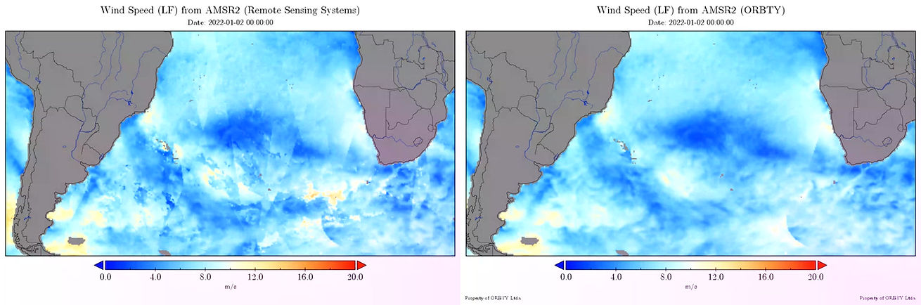
3 days wind speed over the South Atlantic Ocean from AMSR2 for the month of January 2022 derived from Remote Sensing Systems time-averaged product (top) and using ORBTY's M3DFS (bottom)
Column Water Vapor
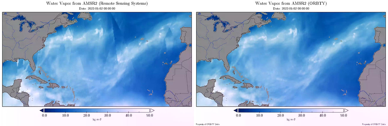
3 days water vapor over the North Atlantic Ocean from AMSR2 for the month of January 2022 derived from Remote Sensing Systems time-averaged product (left) and ORBTY's M3DFS (right)
Sea Surface Temperature
Monthly SST of January 2022 over the North East Atlantic Ocean and the Mediterranean Sea from Terra/Aqua MODIS+SNPP VIIRS.
Products from NASA/GSFC/OBPG (left) and ORBTY (right).


Gradient magnitude of monthly SST (January 2022) over the North East Atlantic Ocean and the Mediterranean Sea from Terra/Aqua MODIS+SNPP VIIRS. Products from NASA/GSFC/OBPG (left) and ORBTY (right).
OCEAN COLOR


Monthly Chlorophyll concentration of January 2022 over the South Atlantic Ocean from SNPP VIIRS.
Products from NASA/GSFC/OBPG (left) and ORBTY (right).


Gradient magnitude of monthly chlorophyll concentration (January 2022 ) over the South Atlantic Ocean from SNPP VIIRS.
Products from NASA/GSFC/OBPG (left) and ORBTY (right).